I live near San Diego where rain any more is as rare as Leap Days; a weather report of “partly cloudy and 25% chance of rain”means that all the prayers in the world won’t get those squalls to spin south below Los Angeles”. On the Dakota prairie, that same weather report means something else entirely.
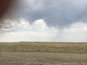
A bit of weather on the South Dakota plains west of the 100th meridian.
Standing in a grassy field with a 360-degree view of an endless horizon, unassuming ash-gray clouds. thicken overhead. In one direction there are two hands of clear blue above a horizon where puffy cumulus clouds perch like fat birds on a wire and sun rays glaze down on distant golden corn fields. A quarter turn and gun-metal gray slants promise the kind of gentle shower that farmers welcome any time of the year. Another quarter turn and a dark sky looks like it might crack open any minute with lightning and downburst blasts or marbles of hail that could flatten a season of corn in ten minutes. The last quarter turn, and the clouds out of the north are intruding on those overhead with that kind of overstuffed mattress look that, a month later in the year, would mean a sure promise of snow. After about 20 minutes in the field and a gentle sprinkle of rain, the sun breaks through and it is a warm fall day.
I am neither the first nor will I be the last to suggest that whomever decided to cut Dakota Territory into North and South made a big mistake; the natural states would have been East and West Dakota. West of the 100 degrees line of West longitude, plus or minus about 50 miles, is a boundary that extends from Canada nearly to Mexico. East of that line enough rain falls to make a living growing crops; west of that line it doesn’t.
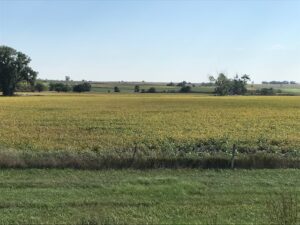
Corn and soy as far as the eye can see in eastern South Dakota.
The western Dakotas are really part of Wyoming: shortgrass prairie ranch lands, black and brown cattle, and tough, weather-beaten homes tucked into places that might hide them from the winter wind. The eastern Dakotas are really part of Minnesota: tall, waving corn fields that assuredly hide small, Stephen King youth cults; endless fields of dense soybeans that, were they only topped with golden-orange flowers, could stand in for the fields where Dorothy and friends fell asleep on the way to Oz; a pragmatic smattering of tall windmills turning in the omnipresent breeze; well-tended farm houses behind trimmed green grass; and even an occasional cheese dairy orphaned from Wisconsin.
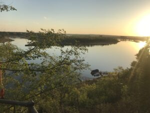
The last 55-mile wild stretch of the Missouri River, longest in America.
The boundary between east and west Dakota is pretty much the Missouri River, no longer “Big Muddy” in the Dakotas as it was nicknamed a century before the six big dams began capturing much of the river’s silt. Today, according to my host in Yankton, Bernie Hunoff, who would probably be nicknamed “Mr. South Dakota” were he not a Democrat, the lake above the Gavins Point Dam that used to be more than 50 miles long is now down to less than 20 miles due to siltation. The last wild section of this longest river in the country moves swiftly, is full of monster-sized paddlefish and sturgeon, and egrets, eagles, and blue herons that nest on the low sand islands.
I think I am too old and spoiled to enjoy winter up here in the Dakotas, but in these balmy fall days, I am loving the place, the pace, and the people here.


Leave A Comment